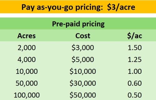
New lower pricing makes Breakline Builder even more attractive!

Now with new lower pricing: The more you buy, the less you pay per-acre!


After your point cloud has uploaded and you start the process, you can expect to get your breaklines within minutes or hours, depending on project size.
Our patented software is already in use by companies with very rigorous accuracy policies, with great results.
Simply upload your bare-earth classified point cloud. You'll quickly be notified when your data is processed and ready for use.
Datasight's cloud-based processing allows you to simultaneously process as many projects as you want.


Create your trial account and you’ll receive 2 free jobs and 100 acres of breaklines, on us!
It only takes a moment to sign up. Then, simply upload your boundary and point cloud or DEM files and our engine will get to work producing beautiful, compact breaklines.

We needed to find ways to do more work with the same staff levels.
The turnaround time is extremely impressive as well with surfaces being ready to download just hours after our data is submitted. Easy, accurate, cost-effective and fast- exactly what we need to stay at the top of our game and grow in today’s market.

We came to the realization that if we were going to continue to grow our business at our target rate, we needed to find ways to do more work with the same staff levels and that made the implementation of DataSight’s platform a no-brainer.
sales@datasightusa.com
304 S Jones Blvd #3546 Las Vegas NV, 89107
866-889-2722